From MEAN Streets to GREEN Streets (Steve Roberts 2007)
http://yorku333.blogspot.com/
=====================================
WHATEVER HAPPENED TO MOVING SIDEWALKS AND
PEDESTRIAN STREET MALLS

Yonge Street pedestrian mall in Toronto (Summer 1973)
(photo source: www.toronto.ca/archives)
In the early 1970’s, for about three summers, most of Yonge St below Bloor St was turned into a giant pedestrian mall with sidewalk cafes. Obviously, Toronto was trying to imitate the successes of the great European pedestrian streets of Stroget in Copenhagen and Drottningsgatan in Stockholm. But the Yonge St mall was only temporary and it disappeared, supposedly, due to excessive loitering and crime issues. What remains today is an ugly street with car exhaust and traffic. It has narrow sidewalks laced with low end stores, pinball parlors, fast food joints, record stores, and other questionable places.

Yonge St near the Eaton Centre, Toronto
(Photo source: www.transcanadahighway.com)
Ironically, the only thing that saves Yonge Street (or destroys it depending who you talk to), is the Eaton Centre shopping mall which was designed to mimic an enclosed street. The inspiration came from the Galleria Vittorio Emmanuele II in Milan.


Top: Eaton Centre, Toronto 1977 (www.eatons.com)
Bottom: Galleria Vittorio Emmanuele II, Milan 1878 (photo source: www.photos.grooky.com)
Here is a brief summary of some excellent books, journals, and websites that I am using in my research:
==============================
==============================
BOOKS:
==============================
==============================
THE CITY AFTER THE AUTOMOBILE: AN ARCHITECT’S VISION.
Moshe Safdie (1997).
GREEN URBANISM: LEARNING FROM EUROPEAN CITIES.
Timothy Beatley (2000). Chapter 10
URBAN SPRAWL: A COMPREHENSIVE REFERENCE GUIDE.
David Soule, (2006). Various chapters and authors.
===================================
THE CITY AFTER THE AUTOMOBILE: AN ARCHITECT’S
VISION. Moshe Safdie with Wendy Kohn (1997). 174 pages
===================================

Reinventing the City and Automobile
============================
This book is insightful and thought provoking. Safdie has almost science fiction ideas about how the city could look and develop without private automobile transportation as its cornerstone. He attempts to envision what the evolution in the city could be and ties them to advances in transportation and construction materials. Electric streetcars gave us the early suburbs in the 1920’s and 30’s. The Otis elevator (along with Bessemer steel reinforced concrete) gave the high-density skyscrapers. The car (with its partner in crime the highway) gave us the sprawling low-density suburbs.
Safdie believes that the car has “devastated the physical fabric of cities” with its traffic, road widenings, and parking problems. He is not a fan of the auto but recognizes it is part of the transportation mix we require. However, besides auto-based urban sprawl, is there another way for urban dispersal to continue in a sustainable and human way? The answer is yes, and therefore, we need to reinvent the city and its transportation system especially with respect to the automobile. Safdie indicates that….
<<_the key to rationalizing transportation in the regional city is to focus first on mobility itself as a goal and second on the best system of transport to satisfy each type of mobility we desire…the regional city if it is to maintain any diversity of architecture, density and balance between natural and man-made environments will require a broad range of speeds, scales, and means of movement_>>
Safdie offers a few ideas to deal with or change the nature regional urban dispersal. Urban dispersal is a big problem not just in North America but in the rest of the world. At the center of this problem is the accommodation of the car. The car has shaped the city and the reshaped city now requires the car. The extent of car based urban dispersal is exacerbated by the fact that parking (and roads) take almost as much as or more space than the building itself. For example, for every 1000 square feet of building: shopping centres need 900 square feet of parking while commercial, housing, universities and hospitals each require 1300 square feet.
He applies all the pollution and congestion arguments of why the car is choking society in order to justify why change is needed. However, when it comes to changing our transportation strategy to be more sustainable, Safdie believes that it is not an “either or” situation but rather multiple solutions will be required.
Safdie speaks of a regional city with “multiple nuclei” connected by a good transportation system that allows us to easily move from one urban centre to another. If a good transportation system can be achieved, the need to duplicate services in each centre will be reduced.
If I apply this concept to Toronto, we have satellite cities such as Brampton, Mississauga, Vaughan, Markham and Pickering that surround the main nucleus of Toronto. As the highway systems expanded to connect these urban centres, a kind of synergy was created. However, these highways became congested and mobility was affected. The cities decided to become more independent. Each attempts to take jobs and residents from the other with the main target being Toronto. The net effect is each city has the same power centres, the same malls, the same cultural centres, and the same recreational centres. We are not moving closer to each other but away from each other as each city claims it is the "best place to live, work, play and raise a family". In essence you do not need to leave the city - ever!
A different emphasis on the type of transportation that we encourage could reverse this trend and the expensive duplication. Less dependence on the private car could make this happen. That does not mean replacing the car with public transit but rather making the car more public. In essence, Safdie advocates the use of the utility car (or U-car) which is similar in concept to the luggage carts used in airports. One picks up and drops off the small cars as needed. A trolley system of cars for personal use is also envisioned. While Safdie’s concept is rather abstract, it is not unachievable. Presently, the Amsterdam airport has such a system of auto-guided cars. At any rate, I do not know think it will solve the congestion problem because as long as we have people who want to travel at the same time to the same place using the same routes then we will have congestion. Nevertheless, private cars and public transit are still very much a part of the transportation equation. Each satisfies a need whether it is for convenience, economic, or social reasons. We just have to learn not to travel all at the same time.
www.carfreetimes.com

Auto-guided shuttle cars at Amsterdam airport
"A House and Garden for Everyone"
==========================
Safdie puts forth the notion that the human desire for a house and garden is common one…
<<_The paradox of contemporary urbanism; the dream of a home and garden that are distant from the ills of the city alongside a desire for the vitality of downtown_>>
Unfortunately, what we desire, what is promised, what is actually built is vastly different than the high-rise condos and cookie cutter houses that everyone is buying and living in.
Moshe Safdie is most famous for his Habitat ’67 housing complex in Montreal. He tried to give the density of apartments close to the city but with a suburban feel. Each home has a garden, several different window views, privacy and individuality. The original concept began by using large Lego bricks and randomly arranging them. He stacked in a cascading manner to almost imitate a Mediterranean village on slope in Greece. He calls “houses in the air”. I believe this Safdie building to be one of the most unique and innovative housing complexes in the world. For environmental reasons and with the need for more compact homes (that are NOT high rise condos), this design is very much applicable in 2007, 30 years later.
Here is Safdie's description of the project:
<<_ Habitat emerged as a structure maximizing exposure with each and every apartment looking out in three or four directions…the result evoked a village, hill town or vertical housing cluster rather than an impersonal behemoth…[after Habitat was built] a change occurred within the residents: corridor became street, apartment became house, and balcony became garden. The pleasure of living with privacy were added to the benefits of living in close community._>>

 www.msafdie.com/
Pedestrian Spine with Retractable Roofs
====================================
The central concept is the idea of an urban pedestrian spine. While this concept is not new, his ideas about what the transportation could look like is different. His ideas range from covered retractable roof streets to horizontal elevators. Safdie describes as follows:
<<_The elevator extends our ability to travel vertical distances…the same principle for vertical conveyance can be applied to horizontal movement: pedestrians can be ferried along the length of the New [Roman] Cardo**…the elevator and the conveyor together would complete the network of full pedestrian access to the contemporary scale of the city [similar to an elevator that has pre-determined floors] a system of cabs could run along horizontal shafts serving a series of programmed stops (and operated by call buttons on the street and destination buttons on the cab)_>>
******************************************
** CARDO or cardus was a north-south-oriented street in [Roman] cities…sometimes called the cardus maximus, the cardo served as the center of economic life.” Wikipedia
******************************************
<<_The Conveyor could eliminate one of the most rigorous constraints in planning during this century: the fact that most individuals travel through a vast road system to a particular spot by personalized vehicle (or mass transportation)- at which point they must enter an urban centre whose dimensions exceed their walking range. [the Conveyor should be laid out and stop positioned to match the major points of access, the transportation nodes, vertical towers and urban landmarks along its length] …the Conveyor could contribute to the vitality and energy of a new kind of public place by extending the area that each mass transit stop and parking depot can serve, making all facilities accessible to the pedestrian and connecting the centre in a powerful way to the rest of the regional city_>>
Modern Day Roman Cardo
======================
<<_The new urban centre would be linear, structured by a spine of intense activity…as a place of maximum interaction in the region, this modern day Roman Cardo would be designed specifically to create an urbanism that invigorates those who move through it, to foster the accidental and spontaneous encounters so central to urban life_>>
According to Safdie, the Cardo would be intersected by many alleyways that would extend the life of the street. Housing would stretch along this cardo however…
<<_In contrast to the dispersed suburbs stretching away on either side along the new cardo would be standing a clustering of high-rise structures to form an edge and look out across the low rise and open landscape – conveniently served by transportation and with walking distance of the concentrated city_>>.
At the terminuses of this Cardo there would be transit, highway nodes in conjunction with parking facility for tourists, work, and residential traffic.
Other Projects by Moshe Safdie
===================
There are many projects by Safdie that exemplify the ideas above:
One of his projects was the rebuilding of Jerusalem’s Mamilla area that, previously, was a no-mans-land war zone for 19 years. Based on the success of pedestrian streets in Copenhagen and Stuttgart he used those streets as a starting point for Mamilla’s “cardo”. The street has sheltered arcades, piazzas, with low-rise offices, hotels, and apartments. The pedestrian is central and parking area is not visible.
Mamilla Jerusalem


Modin in Israel with pedestrian and open space spine down centre

Moving Sidewalks in Terminal 1 Pearson Airport in Toronto
to mitigate the problem of distance for pedestrians


Interstate highway is buried and replaced with greenway in downtown Boston (aka The Big Dig)
Source for all above photos:
www.msafdie.com/***************************************************
OTHER NOTEWORTHY QUOTES (Moshe Safdie)
***************************************************
<<_Despite the distinct differences in scale, resources, climate and history there is a universal pattern…cities are bursting from their traditional boundaries, urbanizing and suburbanizing entire regions…automobiles and their road systems have completely redefined the old boundaries of cities…the regional city encompasses one or more downtowns, industrial, commercial and residential sprawl…urbanization clusters haphazardly along freeway systems…in fact the car and the freeway have become the essence of the regional city_>>
<<__[There are] many conflicting views as to the impact of the exploded city but all agree that on a fundamental conflict – a misfit exists between the scale of the cities and the transportation systems that serve them…we are not able to conform our individual paths of travel with the fixed lines of mass transit…AND THE MORE HIGHWAYS AND EXPRESSWAYS WE BUILD THE SOONER THEY BECOME OVERBURDENED WITH TRAFFIC; NO INVESTMENT IN HIGHWAYS SEEMS GREAT ENOUGH TO SATISFY OUR VORACIOUS NECESSITY TO TRAVEL BY CAR.__>> [my capitalization of sentence]
<<__The auto has devastated the physical fabric of cities….Cities have had to adapt to the growing volume of traffic and needs of off-street parking by widening streets, displacing pedestrians underground or in overhead walkways, cutting new traffic arteries between neighbouring urban districts or through the middle of cohesive neighbourhoods__>>
<<__43% of the worlds 5.5 billion inhabitants live in cities, many of them regional mega-cities which are growing recklessly, increasing in congestion daily and threatening their environment and its resources. If we are to progress we must take lessons from the megacity not the Italian hill town nor the American pre-industrial village. We must study the airport, the megamall, the convention centers, the enormous parking lots and structures, the freeways and their interchanges, the sprawling strip developments along highways for an understanding of the current needs, contemporary behaviour and real economic necessities. We need not accept them but we must understand the powerful patterns that shape the city today__>>
<<__[Projects that solve urban problems by trying to imitate idyllic past settlement patterns] rely on social, economic and political conditions that cannot by any reasonable measure of realism be seriously obtainable in the face of the urban ills affecting the vast majority of the global population: ever increasing densities, diminishing environmental and land resources, hugely scaled manufacturing and retail facilities, increasing car ownership, traffic and parking needs. For an architect in Singapore, Hong Kong or Tokyo contemplating new residential communities of hundreds of thousands of people each of an average density of 50 to 100 units per acre, the problem of scale is real: it is the result of fundamental changes to the statistical condition of humanity. And in this context, the argument that it can be avoided by “rearrangement” appears to be naïve and misdirected.__>>
<<__ Most cities are failing to plan in conjunction with one another…while many cities proclaim autonomy, most have become inextricably part of an expanded city. Woven into the culture of the region, residents of these enclaves choose their places of work and recreation from a broad range of possibilities (e.g. services, cultural, commercial, education, hospitals) that the region has to offer…[in addition] they share regional road systems and public transportation networks__>>
<<__ Extensive suburban migration that has created our dispersed cities is not only a response to the growth and congestion in the city center but also a profound cultural and psychological desire – omnipresent in North America - for freedom, expansiveness, privacy and flexibility… let’s not confuse cause and effect, people are moving outward to get away from the city not because suburbs are being built__>>
<<__ The “city after the automobile” is a broad network of dispersed, low rise residential neighbourhoods mixed with open land reserves – and a number of dense, intensive districts replete with culture, commerce, services and entertainment…STREAMLINING INTERFACES AMONG ALL SCALES OF TRANSPORTATION WILL BE THE KEY TO MAKING TRAVEL AMONG CONCENTRATED PEDESTRIAN DOWNTOWNS, DISPERSED SUBURBS, AND PRESERVED OPEN SPACES EQUALLY ACCESSIBLE AND EFFICIENT…[each environment and mode of transportation must be addressed for each situation] to serve dispersal, we must adapt the car; to connect areas of concentration we must institute rapid trains; to travel with reasonably concentrated districts, we must support local subway and light-rail systems __>>
<<__ We do not live or work “en masse” therefore we cannot travel entirely en masse by public transportation no matter how much it is improved__>>
===================================
GREEN URBANISM: LEARNING FROM EUROPEAN CITIES.
Timothy Beatley (2000).
Building Ecologically: Designing Buildings and Neighbourhoods with Nature in
Mind (Chapter 10).
===================================

Chapter 10 relates to designing buildings and neighbourhoods to be sustainable ecologically. Again countries like the Netherlands, Denmark, and Germany are leading the way. In the Netherlands alone, there have been 14,000 sustainable homes built between 1991 and 1995.
The projects to follow have common attributes according to Beatley:
1. High conservation of energy
2. Low usage of water
3. Green building materials
4. Recycling and reuse
5. Solar energy
6. Minimal reliance on the auto
7. Close to public transit
8. Walking and cycling options
Here are some unique features:
ECOLONIA (Alphen a/d Rijn), NL: 100 units surrounding common pedestrian area. Medium density 10 buildings each with 10-18 homes. Set standard for other developments to follow. Built: 1989-1992.
MORRA PARK (Drachten), NL: 125 units using passive solar and active solar energy. Storm water runoff collected and water supply is closed loop canal system. Other features include: restricted parking, permeable surfaces, work at home units, preserved green areas, bike paths, vegetable gardens and composting areas, sustainable building materials, 40% reduced energy consumption. Built: 1989-1991.
ECODUS (Delft), NL: 250 units similar features to Morra Park but with low parking ratio of 1:1, natural wetland purification system. More importantly viewed by government as model for future development. Finally there was little architectural experimentation: “normal development for normal people”. Built: 1990-1992.

(photo source:
www.dubo-centrum.nl/projecten/project.php?recID=78)
OIKOS (ENSCHEDE), NL: cluster development with natural open space and natural drainage. Community centre, rapid bus terminal and retail in the centre of neighbourhood. “Green fences”, bicycle connections, and a series of walkways leading to town centre

(photo source:
www.arcos-architecten.nl/bijzon/enschede.html)
IJBURG, AMSTERDAM, NL: Designed to minimize its ecological impact. This government development is dense at about 60-110 dwellings per hectare. Supported by tram system to be followed by subway expansion. Many areas are car-free with low number of parking spaces. Residents are offered reduced rate transit membership and car sharing programs. Living spaces are designed for low energy and minimal pollution.

Part of Ijburg is also a student residence
(photo source:
home.student.uva.nl/~0302147/ssc/ijburg_10-05-2005_02.jpg)

Tram goes in BEFORE construction starts
(photo source:
www.tramfoto.nl/IJB03_0251G.jpg)


Compact housing with tram line, bicycle, and walking paths
(photo source:
www.steigereiland.com/fotos/inrichting-van-steigereiland/?page=5)
WEBSITE TRANSLATION from DUTCH into ENGLISH go to URL link and paste in address:
world.altavista.com/babelfish/trNORTH AMERICA IS LAGGING BEHIND THE SUSTAINABLE BUILDING GAME
==================================
There is not much real substance in North America when it comes to sustainable development. Beatley complains that many North American “ecological” housing developments are located in low-density car dependent suburbs. There is a provision for conserving greenspace and the density may be lower but not low enough. Ultimately the question to ask is: does it really significantly reduce the environmental impact or footprint?
Unfortunately and sadly, only 2 or 3 developments in North America are noteworthy including Toronto’s Healthy House according to Beatley.


Canada Mortgage and Housing Corporation (CMHC)
(photo source:
www.cmhc-schl.gc.ca/en/inpr/su/index.cfm)
===> Beatley indicates that in all these European cases, the one main reason for success is active role of the government as facilitator and catalyst. Not only from an capital investment point of view but also with respect to financial incentives such as “green mortgages” that provide home owners with reduced interest mortgages for eco-friendly homes.
***********************************
NOTEWORTHY QUOTES (T. BEATLEY)
***********************************
<<__Northern Europeans have made major national commitments to advancing ecological building often with substantial and creative financial underwriting and through other important forms of national and municipal leadership…however, the American situation (in contrast) can best be characterized as a haphazard, scattered set of buildings and projects (instead of a serious commitment to ecological building and design) which is driven more by enlightened clients and specific designers than by strong public policy.__>>
===================================
URBAN SPRAWL: A COMPREHENSIVE REFERENCE GUIDE.
David Soule, (2006).
Ch1. Defining and Managing Sprawl
Ch2. Historical Framework
Ch4. Planning Framework
Ch8. Political Framework
Ch10. Transportation Systems
Ch13. The Impact of Sprawl on the Environment and Human Health
Ch14. The Cost of Sprawl
Ch20. The Local Arena
===================================

Sprawl has become synonymous for bad urban development. It has come to symbolize the contradictory nature of society. On one hand, we encourage it with tax incentives and subsidized highway building and call it economic development, on the other hand, we consider sprawl the reason for our planets decline (and eventually demise) both environmentally and socially.
The book a useful reference guide to understanding the reasons for sprawl. This book in makes an excellent case for actual cost or honest pricing of transportation. Currently, gas prices and road building is massive subsidized by government at all levels under the guise that it is good for the economy. Any attempts to reign in sprawl would be futile if the subsidies are not removed
There is no doubt that everyone wants a big house and yard in the country with no traffic congestion. However, the reality that someone has to pay for all this but it should not be the rest of society (especially those individuals who do not benefit). Those who choose to be part of sprawl should pay for the ongoing and upfront infrastructure costs completely (e.g. highway, sewage). Conversely, those that live in more compact developments in the city should benefit with lower costs.
***********************************
NOTEWORTHY QUOTES (various authors)
***********************************
CH1-DEFINING AND MANAGING SPRAWL (D. SOULE)
==============================
<<__Sprawl is an elusive and pejorative name [for]… low density, auto-dependent land development taking place on the edges of urban centres, often leapfrogging away from current denser development nodes, [in order] to transform open, undeveloped land, into single-family residential subdivisions and campus-style commercial office parks and diffuse retail uses__>>
CH2-HISTORICAL FRAMEWORK: CITIES AND THEIR REGIONS, SUBURBANIZATION AND FEDERAL POLICIES (D. SOULE)
===================================
<<__The relationship between land use, transportation and open space created a profound influence on the layout of federal subsidized highway network…as early the 1920’s…these same subsidies were not available to railroads and urban transit systems. These [transit systems] would remain in private hands well into the 1950’s until finally the franchises were relinquished back to the cities and states as owners went bankrupt. Federal support for these systems would take even longer to develop and continue to be more difficult to sustain without the subsidies contributed by the motor fuels tax to the highway trust fund __>>
CH4-PLANNING FRAMEWORK: A PLANNING FRAMEWORK FOR MANAGING SPRAWL (R.WILLMER)
===================================
<<__ Growth management is a systematic approach to regulating growth that attempts to steer development to areas where growth is appropriate while protecting those areas where resource protection is an important concern. The goal is to maximize the benefits of growth and protect areas where new development should be minimized.__>>
<<__ The underlying principle of smart growth is the preservation of land and natural resources. On both the local and regional levels, environmental resources, agricultural and forest lands, and open spaces can be protected through more compact building forms, infill and brownfield redevelopment, and some reduction in the requirement for wide streets and excessive parking. More compact development patterns also reduce the dependence on the automobile by shortening or eliminating trips, thereby creating less pollution and energy consumption__>>
<<__The denser development argument to reduce cars seem counter logical since denser development like [found in] the city means more cars and traffic – denser development offers alternatives to the car such as walking and transit __>>
<<__ The cookie cutter type of development pattern is encouraged or even required under current municipal land use regulations. Development that incorporates the principles of smart growth is either prohibited outright or would require special permits that lengthen the permitting process, thereby creating disincentives for developers__>>
CH8-POLITICAL FRAMEWORK: THE POLITICS OF SPRAWL (D. SOULE)
===================================
<<__ Americans have a problem with the concept of density. Dense means crowded. We need to change our language if we are going to convince people that large lot subdivisions are not the only answer to family residential choice (Robert Grow)__>>
CH10-TRANSPORTATION SYSTEMS: MARKET CHOICES AND FAIR PRICING
(C. JOHNSON)
===================================
<<__ In one respect congestion is a success story, it is visible evidence that a growing population has the money and motivation to go places…many of the most envied regions anywhere are congested places…congestion is a positive sign when long lines form for a great concert, movie or restaurant…however congestion on roads has always attracted criticism __>>
<<__Congestion is only a symptom. The problem is the system that sponsors a spread out growth pattern coupled with nearly total dependence o the personal vehicles __>>
HONEST PRICING
--------------------------------
<<__ Honest pricing simply means full disclosure of full costs…the estimated cost from land development impacts and transportation services could be more directly reflected in the hierarchy of decisions that now govern investor, developer, and buyer behaviour (Ryan and Stinson 2002). An honest price might slow the conversion of fresh land for development, stimulate more creative redevelopment in existing communities and provide resources and incentives for investment in transportation alternatives__>>
RELIEVING CONGESTION ONLY FURTHER PROMOTES SPRAWL
--------------------------------
<<__ Transportation decisions can have the effect of promoting inefficient land development…shelter and mobility may start out as very separate concerns for most people. But in economic systems, they inevitably become entangled…[fundamentally] when the demand for any good increases, the price of a complimentary good is likely to fall….if the cost of buying a car goes down [or the gas as well] the demand for automobile-oriented destinations goes up.. So as people conclude that owning and operating a vehicle is cheap, relative to other costs, their demand for homes and job locations becomes less sensitive to distances they will have to travel. __>>
THE REAL USERS SHOULD PAY:
--------------------------------
<<__In order to slow the rate of new land conversion we need to expose users of the road to a larger share of pubic cost (Ryan, Stinson 2002)…currently government taxes, property taxes and motor vehicle registration taxes cover 70%…MUCH OF THE COST IS BORNE BY LOW MILEAGE HOUSEHOLDS OR PEOPLE WHO DO NOT DRIVE AT ALL…without changing the total revenue collected, the 70% ratio could be reversed…To illustrate, suppose that the state income and sales taxes now going for transportation…were eliminated and that the property taxes and motor vehicle registration tax [was reduced]…Instead collect that revenue through the motor fuels tax.…or tax the miles driven to finance the marginal cost of the system…the system as it stands now rather radically hides the true costs from users (Ryan and Stinson 2002). __>>
<<__Today’s tax system for transportation (roads and transit) is only partially driven by use…the threshold of a tax shift that would translate into measurable market behaviour change is probably relatively high. ROAD SYSTEM COST WOULD HAVE TO BE MORE VISIBLE AND DIRECTLY PAID BY USERS FOR THEIR IMPACT TO CHANGE BUYING DECISION BEHAVIOUR…[an increase in annual commuting costs would influence commuting distance (decrease) and the gas efficiency of the vehicle (SUV to compact).__>>
CH13-THE IMPACT OF SPRAWL ON THE ENVIRONMENT AND HUMAN HEALTH (S.GARDINER)
===================================
==>Average car burns 550 gallons of gas per year and 8800 pounds of C02 (SUV’s, minivans are double)
<<__Pollution from suburban excess produces global effects. The increase in driving necessitated by sprawl has led to more greenhouse gas emissions, more than 33% from vehicles (Heart 2002). Clearing forest and fields for new roads, driveways and building sites destroy carbon sinks…exacerbating the effects of increased auto emissions. CO2, the principle contributor to climate change has risen 30% since the pre-industrial era (NJ Dep 2003) The earth is warmer now than it has been in the past 2000 years. The US accounts for 34% of global CO2 emissions (BTS 1996) __>>
<<__Large lots were once thought to protect water quality by reducing the percentage of the lot covered by a building’s footprint. However, it is now known that the more extensive road and driveway network necessary to connect the houses in large lot subdivisions actually increases the percent of impervious coverage to 10 to 50% above that of cluster development or traditional town centers (Getting a Rein on Runoff: How sprawl and the Traditional Town Compare. South Carolina Conservation League 1995)__>>
CH14-THE COST OF SPRAWL (D. SOULE)
===================================
<<__Garreau’s study of edge cities is primarily anecdotal and qualitative. He points to an observable phenomenon that communities on the fringes of metropolitan areas are becoming important in their own right. This causes metropolitan areas to develop multi-centric or poly-nucleated configurations where edge cities compete for jobs people infrastructure funds and other resources against traditional central cities (Garreau 1988
Galster and Hanson 2001 put factor to consider when determining the existence and extent of sprawl:
1. Density
2. Continuity
3. Concentration
4. Clustering
5. Centrality
6. Nuclearity
7. Mixed uses (different land uses in the same area)
8. Proximity (different land uses close to each other)
__>>
==============================
==============================
JOURNAL ARTICLES
==============================
==============================
1. PAYING THE COSTS OF SPRAWL: USING FAIR-SHARE COSTING TO CONTROL SPRAWL. Ken Snyder, Lori Bird 1998. (37 pages)
www.smartcommunities.ncat.org/articles/sprawl.pdfExcellent journal article looking at how sprawl is subsidized and how we can better allocate resources to discourage auto-based sprawl and encourage more intense forms of development. The goal is to distribute costs to those who generate the costs.
<<__Sprawl is as much a product of poor land use planning, skewed market mechanisms, uneven tax policies, and fragmented government bodies as it is a product of personal preferences.__>>
Indirect and direct subsidies for driving in the USA amount to $184 billon per year. The breakdown is as follows with indirect subsidies represent 67% of total costs.
Direct Subsidies=$59 Billion:
--------------------------
$31B State and Federal Highways (less user fees and tolls)
$9B Municipal and country streets
$1B Strategic Petroleum Reserve
$18 Military protection of oil supplies
Indirect Subsidies=$125 Billion:
--------------------------
$36B Accidents (uncompensated)
$62B Air pollution
$6B Water pollution
$8B Noise pollution
$13B Global warming
***********************************************
2. MAKING TORONTO’S STREETS (2006). Hess, P., Milroy, B.; University of Toronto, Ryerson University. (Toronto Streets Report Sept 2006.pdf)
www.cuhi.utoronto.ca**Excellent** report on making Toronto more pedestrian and transit oriented.
100 pages

The configuration of streets or the lack of “catwalks” can make walking distances unnecessarily longer than they should be.
3. DEVELOPMENT IMPACT FEES: IS LIMITED COST INTERNALIZATION ACTUALLY SMART GROWTH? (Nick Rosenberg) Boston College Environmental Affairs. .
www.bc.edu/schools/law/lawreviews/meta-elements/journals/bcealr/30_3/09_FMS.htm4. GREEN URBANISM: THE MOVE TOWARDS ECOLOGICAL CITIES (2006). Tim Beatley
www.seattle.gov/dpd/stellent/groups/pan/@pan/@sustainableblding/documents/web_informational/dpdp_016999.pdf**Excellent** slides and summary of ecological living in Europe

5. RESIDENTIAL STREET PATTERN DESIGN. Canada Mortgage and Housing Corporation (CMHC).
www.cmhc-schl.gc.ca/odpub/pdf/62486.pdf6. APPLYING FUSED-GRID PLANNING IN STRATFORD, ONTARIO. Canada Mortgage and Housing Corporation (CMHC)
www.cmhc-schl.gc.ca/odpub/pdf/63760.pdfStreet ends are “fused” to create cul-de-sacs and block car traffic. However, these fused streets are still open to pedestrian traffic with greenspace connectors.

7. CHANGING THE RESIDENTIAL STREET SCENE. (Ben-Joseph, Eran) Journal of the American Planning Association; Autumn95, Vol. 61 Issue 4, p504, 12p
8. NBWS-THE NATIONAL BICYCLING AND WALKING STUDY - TRANSPORTATION CHOICES FOR A CHANGING AMERICA; Final Report, FHWA, 1994, FHWA-PD-94-023
www.fhwa.dot.gov/environment/bikeped/study/index.htm9. CREATING A HEALTHY ENVIRONMENT: THE IMPACT OF THE BUILT ENVIRONMENT ON PUBLIC HEALTH. Centers for Disease Control and Prevention. Jackson, Richard J., MD, MPH; Kochtitzky, Chris, MSP,
10. CAR-FREE CITIES - MYTH OR POSSIBILITY? EXPLORING THE BOUNDARIES OF SUSTAINABLE URBAN TRANSPORT, 1999. McKenzie, Catherine, 'World Transport Policy and Practice 5 (1)
11. CAR-FREE HOUSING IN EUROPE: A NEW APPROACH TO SUSTAINABLE RESIDENTIAL DEVELOPMENT, Scheurer, Jan. Discussion Paper, Institute of Science, Technology and Planning, Murdoch University, Australia –
www.sustainability.murdoch.edu.au/publications/jscheurer/carfree/carfree.htmlExcellent report on carfree projects in Europe. Useful weblinks and bibliography. Carfree projects profiled include:
-Amsterdam, GWL-terrein
-Edinburgh, Slateford Green
-Hamburg, Stadthaus Schlump
-Vienna, Autofreie Mustersiedlung Floridsdorf
-Freiburg, Vauban
-Hamburg, Saarlandstraße
12. CAR-FREE DEVELOPMENT: THE POTENTIAL FOR COMMUNITY TRAVEL PLANS 2005. Morris, David. Transportation Studies Group. Department of Civil and Building Engineering, Loughborough University.
<<__There is a difference between visually car-free or traffic-free and actual car-free where ownership is restricted- [car-free neighbourhoods] will only decrease for need of car for local destinations but may not necessarily prevent long distance or commuting trips.__>>
<<__Car free should improve the quality of life rather be anti-car or decrease the quality of life. For example, some land saved from road could be put towards more open space and play areas for kids__>>
13.
THE END OF THE URBAN FREEWAY. Newman, P. (p6-)
HOW AMSTERDAM PLANS TO REDUCE CAR TRAFFIC. Lemmers, L. (p19)
NEW ROADS GENERATE NEW TRAFFIC. Pfleiderer, R. & Dieterich, M. (p23)
LIVING WITHOUT A CAR. Glotz-Richer, M. (p39)
World Transport Policy & Practice (WTTP), Eco-logica Ltd. Index 01 Volume 1, 1995 Abstracts 01
The shine of highway and road building is starting to fad. There is a growing belief that we need to build cities that are less car dependent. It is no longer viable (socially, economically and environmentally) to build highways indiscriminately under the guise of economic progress. However, if car-free housing is to be successful, then housing and work locations should be relatively close so the "commute" does not become a major obstacle to quality of life.
IMPROVED TRANSIT ONLY WILL NOT REMOVE CARS FROM THE ROAD
In Amsterdam, traffic reduction initiatives attempt to promote more sustainable forms of transportation in order to keep the city centre core thriving. In Stuttgart, one report found that there was no data to support the idea that improved transit will remove cars from the road:
<<__any measure that makes road traffic faster induces new traffic. Any measure that makes road traffic slower reduces traffic…systems of mass transportation can contribute to environmental protection only if improvements in public transport are paralleled by measures to decelerate motorized traffic, thus allowing for changes in the modal split without increasing overall traffic__>>
14. LEARNING FROM EUROPE. Masser, I. Journal of the American Planning Association; Winter 1992, Vol. 58 Issue 1, p3, 6p
15. INFILL TOWNHOUSES (2003). Toronto Urban Design. Guidelines, Building, Type. City of Toronto.
16. CAN PLANNERS HELP PROTECT THE MOBILITY OF AN AGING POPULATION (2005). Miller, G.;Harris, G.; Ferguson, I.; Canadian Urban Institute
www.canurb.com/aging/17. SMART GROWTH IN CANADA (2001). Canadian Urban Institute.
www.mah.gov.on.ca/userfiles/HTML/nts_1_23005_1.html18. THE STIMULATION OF BICYCLE USAGE IN EUROPEAN CITIES (2002). Zuks, R.
www.sustainability.murdoch.edu.au/casestudies/Euro_Field_Trip/eurotrip2002.htm19. AUTO-DEPENDENT INDUCED SHOPPING: EXPLORING THE RELATIONSHIP BETWEEN POWER CENTRE MORPHOLOGY AND CONSUMER SPATIAL BEHAVIOUR. Brian Lorch. Canadian Journal of Urban Research. Winnipeg: Winter 2005.Vol.14, Iss. 2; pg. 364, 20 pgs
Unlike enclosed shopping malls that are pedestrian-friendly, power centres provide little or no walking facilities and encourage the shopper to drive to each store within the complex.

Vaughan Mills Centre: One large building in a sea of parking
(photo source: maps.google.ca)

Vaughan’s 400 & 7 Power Centre: Many small buildings in a sea of parking
(photo source: maps.google.ca)
20. PRIVATE STREETS: A SURVEY OF POLICY AND PRACTICE. Andrew Curran, Jill Grant. Canadian Journal of Urban Research. Winnipeg: 2006.Vol.15, Iss. 1; pg. 62, 17 pgs
21. TOWARDS SMART GROWTH? THE DIFFICULT IMPLEMENTATION OF ALTERNATIVES TO URBAN DISPERSION. Filion, Pierre. Canadian Journal of Urban Research. Winnipeg: Summer 2003.Vol.12, Iss. 1; pg. 48
22. URBAN SPRAWL OR PLANNED DEVELOPMENT. The Land Economist (Fall 2004) vol34no3, p4
23. IMPACT OF URBAN FORM AND TRAVEL ACCESSIBILITY ON PRIVATE VEHICLE USE
www.cmhc-schl.gc.ca/odpub/pdf/62422.pdf24. CAR-FREE HOUSEHOLDS: WHO LIVES WITHOUT ANY AUTOMOBILE TODAY?' (1996). Reutter, Ulrike & Reutter, Oscar, World Transport Policy and Practice 2 (4).
==============================
==============================
WEBSITES
==============================
==============================
***********************************************
1. SUSTAINABLE MODEL DISTRICT VAUBAN
***********************************************
English Abstract:
www.vauban.de/info/abstract.htmlMore photos of Vauban:
www.vauban.de/rundgang/index.htmlWEBSITE TRANSLATION INTO ENGLISHVauban is located near Freiburg, Germany. It is an ecologically sustainable community of 5000 people and supporting 600 jobs. It is one of the largest solar projects in Europe. Some buildings are new and but many buildings are converted army barracks.
==>>>>> Here are the features:


==1== Low energy use homes- Passive solar homes not reliant on conventional heating systems.
==2== Solar collectors are used to heat water and photovoltaic cells are used to generate electricity.
==3== High efficiency co-generation plant using wood chips to power many homes.

==4== Cluster housing configured to be private and individual.
==5== Mixture of private home ownership and co-op arrangements

==6== Reduced auto dependency. About 40% of residents live without a car.
==7== Car free or car restricted streets: only pickup and delivery. Only common parking available (i.e. No parking at doorstep).

==8== Streets and public spaces are playgrounds and places of social interaction

==9== Good access to public transportation (tram line, direct bus to train station).
==10== Greater use of green building materials.

==11== Employment, shops, schools, and community centre located within walking or cycling distance.
==12== Car sharing options available
==13== Green roofs and reuse of rainwater or diversion back into the ground.
==14== Household organic waste provides fuel to biogas plant.
***********************************************
***********************************************
2. NRDC ENVIRONMENTAL CHARACTERISTICS OF SMART GROWTH NEIGHBORHOODS. CASE STUDIES IN SACRAMENTO AND NASHVILLE
www.nrdc.org/cities/smartGrowth/char/charinx.asp3. SMART COMMUNITIES NETWORK- GREEN DEVELOPMENT BENEFITS & BASIC ELEMENTS
www.smartcommunities.ncat.org/greendev/benefits.shtml4. SUSTAINABILITY- CANADA MORTGAGE AND HOUSING CORPORATION (CMHC)
www.cmhc-schl.gc.ca/en/inpr/su/index.cfm5. Autofreies Wohnen (Auto+free living: Living Without the car)
www.autofreieswohnen.de/kornweg/files/autofrei.htmWEBSITE TRANSLATION INTO ENGLISH6.WOHNEN PLUS MOBILITAT (“LIVING AND MOBILITY”)
www.wohnen-plus-mobilitaet.nrw.de/wohnen_ohne_auto/wohnprojekte/index_e.htmlThis website is a good resource showing proposed car-free housing developments in Germany. Some cities include: Berlin, Bremen, Freiburg, Köln, Munich, and Münster


Car-free neighbourhood designs: Munich (L) and Berlin (R)
7. E-DESIGN CITIES WITHOUT CARS
www.state.fl.us/fdi/edesign/news/9708/reviews/cwc.htm8.BREMEN:URBAN DISTRICT PLANNING WITHOUT CARS
www.eaue.de/winuwd/56.htm9. VICTORIA TRANSPORT POLICY INSTITUTE (VTPI)
Extensive resources and references.
== A. CAR-FREE PLANNING
www.vtpi.org/tdm/tdm6.htm== B. SMART GROWTH
www.vtpi.org/tdm/tdm38.htm== C. LAND USE DENSITY AND CLUSTERING
http://www.vtpi.org/tdm/tdm81.htm== D. LAND USE EVALUATION
www.vtpi.org/tdm/tdm104.htm10. MW DECENTRALIZED AND BUILDING INTEGRATED PV SYSTEM IN A NEW HOUSING area of Amersfoort Case studies: Netherlands
www.oja-services.nl/iea-pvps/cases/nld_01.htm11. IBA-SIEDLUNG KÜPPERSBUSCH (“KUPPERSBUSCH SETTLEMENT”)
www.oekosiedlungen.de/kueppersbuschWEBSITE TRANSLATION INTO ENGLISH12. DOWNTOWN MARKHAM
www.downtownmarkham.ca/view/index.phpInnovative plans to create a new pedestrian-friendly and transit oriented downtown.


A wide avenue for pedestrians and buses only is proposed for Markham's new downtown
***********************************************
13. INSTITUTE FOR SUSTAINABILITY AND TECHNOLOGY POLICY
www.sustainability.murdoch.edu.au14. CEES BAKKER – HEERHUGOWAARD HOLLAND (“SUN CITY”).
www.cees-bakker.nl/


Solar collectors to heat water and photovoltaic cells to create electricity on
roofs of this housing development in Heerhugowaard, Holland.
15. CBC INTERVIEW (1997) WITH MOSHE SAFDIE (THE CITY AFTER THE AUTOMOBILE)
archives.cbc.ca/IDC-1-74-1427-9353/people/moshe_safdie/clip716. “RÖTHELHEIMPARK”, ERLANGEN, BAVARIA, GERMANY
www.werkstatt-stadt.de/ipros/03_suche/index.php?gt=1WEBSITE TRANSLATION INTO ENGLISHwww.oekohof.de/passivhaeuser.htmWEBSITE TRANSLATION INTO ENGLISH 
Ecological house with solar panels (photovoltaic cells)
17. LESSON 5 ADAPTING SUBURBAN COMMUNITIES FOR BICYCLE AND PEDESTRIAN TRAVEL. FHWA Course On Bicycle and Pedestrian Transportation USDOT Federal Highway Administration.
safety.fhwa.dot.gov/ped_bike/univcourse/swless05.htm18. LESSON 6 NEO-TRADITIONAL NEIGHBORHOOD DESIGN. FHWA Course On Bicycle and Pedestrian Transportation USDOT Federal Highway Administration.
http://safety.fhwa.dot.gov/ped_bike/univcourse/swless06.htm19.L’AVENUE MONT-ROYAL: PREMIERE AVENUE VERTE A MONTREAL
(MONT-ROYAL AVENUE: MONTREAL’S FIRST GREEN AVENUE).
sgag.dyndns.org/avenueverte5/PagesWeb/PresentationProjet.htm 
Montreal’s innovative plan to reconstruct the road to accommodate people, trams, and bikes instead of the car.
20. THE STRASBOURG TRAM
www.tram-strasbourg.com/cgi/index.php?wpage=networkStrasbourg, France is converting many of its car roadways into tramways where trams are the dominant mode of transportation. Note the grass used to reduce the impermeable surfaces and improve aesthetics


From MEAN Streets to GREEN Streets
21. TRAM DE STRASBOURG
sites.estvideo.net/docspage/tramways/tramsg/tramstrasbourgprincipale.html 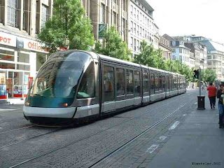
Modern trams replace autos as the main mode of transportation
22. EVA-LANXMEER, CULEMBORG, NETHERLANDS
www.bel-lanxmeer.nl/

EVA-LANXMEER, CULEMBORG, NETHERLANDS
Ecologically sustainable community in Laxmeer, Culemborg, NL. Energy efficient homes, electricity generated by photovoltaic cells, hot water from solar collectors. Limited car access and parking with car-sharing programs. Rainwater treatment and on-site purification of community waste water.
23. PASSIVHAUSIEDLUNG KRONSBERG, HANNOVER, GERMANY
(“SOLAR HOUSE ECOLOGICAL SETTLEMENT”)
www.oekosiedlungen.de/kronsberg/ ENGLISH TRANSLATION


KRONSBERG: Pedestrian oriented and ecologically sustainable development with solar panels and environmentally sound ways of dealing with storm water
24 .STEIGEREILAND FOTOBOEK
Compact and energy efficient housing under construction in Ijburg, NL
www.steigereiland.com/fotos/inrichting-van-steigereiland/FOR WEBSITE TRANSLATION DUTCH TO ENGLISH - COPY AND PASTE WEB ADDRESS HERE:
world.altavista.com/babelfish/tr25. EUROPEAN GREEN CITIES NETWORK (EGCN)
www.europeangreencities.com/demoprojects/demoprojects.asp/Best practices website with demo low energy housing projects across 11 countries in Europe


